

The Place Name “Law” near Walton-le-Dale (Lancashire) – Identified
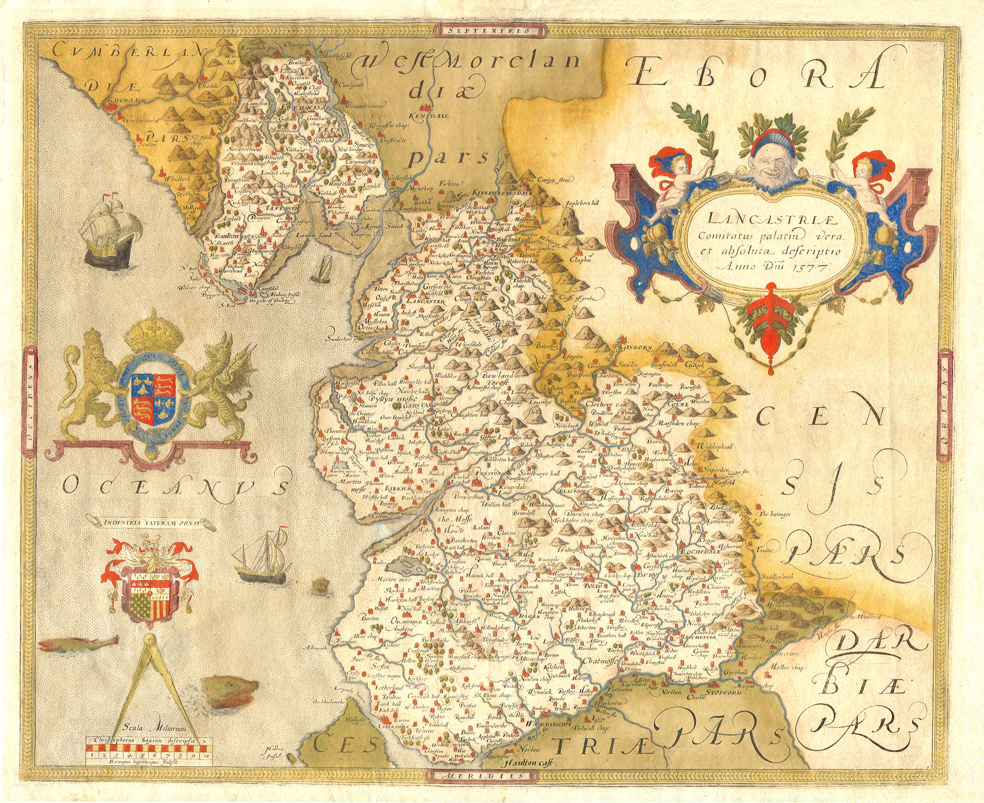
I recently came across some old maps of Lancashire when searching for an Ordnance Survey Six Inch First Edition map that is currently missing from the National Library of Scotland website. These maps are hosted online by the Lancaster University Library Map Collection. I had seen some of them before, a notable one was John Speed’s map, which was made in the early 17th century. However, many of them I had not encountered before. When glancing over them, I was drawn to a place name that appeared to be in the proximity of Walton-le-Dale. It looked strange, and I cannot recall seeing it before. The place was identified as “Law“.


A bit of investigation revealed that ‘Law’ might be something related to a hill (Old English hlāw, meaning hill or mound). My first thought was that it could be the hill on which Hoghton Tower stands. However, when looking at more than one of the maps, I could see that Hoghton Tower was identified separately in some cases, so this could not be Law.
The Internet (web) search led me to a book by Eilert Ekwall, called “The Place-Names of Lancashire”, which was published in 1922. It is available via Archive.org
Ekwall writes the following:
BLACKBURN PAR. (Blackburn Parish)
This parish forms the W. part of the hundred, being separated from Whalley parish by the Calder, the Hyndburn, and the moors S. of the source of the latter river. It consists of a district on the S. bank of the Ribble and a broad area on both sides of the upper Darwen. The surface varies considerably. In the
S. Darwen Moor reaches 1,320ft. From there the ground slopes towards the
Ribble, but there are several minor hills, as Mellor Moor, Billington Moor, etc.Walton-le-Dale (on the Ribble S. of Preston, v.) : Waletune DB, Waleton 1246 LAR, Walton in La Dak 1304, 1332 LF, Walton in Le Dale 1318 LF, etc.,
Walton in the Dale 1332 LS. O.E. Walatun ” the tun of the Britons.” Low Chapel (former name of Walton church) : Capella (ecclesid) de la Lawe 13 cent. WhC 90, locum de la Lawe 1283 ib. 114, Law 1577 Saxton, 1577 Harr.
O.E. hldw ” hill.” The church stands on a slight eminence.

~
Summary:
The recurring place name “Law”, found on several early maps of Lancashire between the Rivers Ribble and Darwen, has long been obscure. It appears in:
- Saxton’s 1577 map (as Law),
- Christopher Saxton’s maps in subsequent atlases,
- and even as late as the 1662 Blaeu map (where both Hoghton Tower and Law are marked as distinct features).
This caused some confusion as Law was shown as a discrete settlement or landmark south of Preston, in a broadly correct geographic location, but had fallen out of common modern usage.
Identification:
The mystery was solved through a reference found in:
Eilert Ekwall, The Place-Names of Lancashire (1922) – Available via Archive.org
In his entry for Walton-le-Dale, Ekwall records earlier names such as:
- Waletune (Domesday Book),
- Walton in La Dale (1304, 1332),
- and most importantly:
Low Chapel (former name of Walton Church): Capella (ecclesia) de la Lawe (13th century), locum de la Lawe (1283), Law (1577 Saxton)
This confirms:
- “Law” is a historical name for the site of St Leonard’s Church, which stands on a small hill (Old English hlāw, meaning hill or mound).
- It aligns with the 1577 Saxton map’s label “Law” being placed near this location, indicating that cartographers of the period were marking a known ecclesiastical site with its local topographical name.
~
It seems likely that whoever was referring to the Walton Church (now St Leonards) as Low Chapel, in historical records, should probably have been calling it “Law Chapel“.
This section about
‘LANCASHIRE CHURCH SURVEYS, 1650, BLACKBURNE [BLACKBURN] HUNDRED. BLACKBURN PARISH.’
does identify the place as ‘Law Chapel’
It comes from
‘THE RECORD SOCIETY, RELATING TO LANCASHIRE AND CHESHIRE, REPORT FOR THE YEAR 1878-9.’

Law, a pochiall Chappell, distant from the pish Church of Blackburne nyne myles (to wch is anexed the Townps of Walton & pte of Cuardale) [Cuerdale], consistinge of aboue Twoe hundred ffamilies, hath ffourtie pounds p anñ allowed by ord of the Comittee of plundred Ministers out of the sequestred tyths of James Anderton, a papist Delinqt, But in regard of other charges laid vpon the sª tyths for the mayntenance of other Ministers the Inħaits haue reca noe benefitt of the sª Ord, besyds they had formly foure pounds pann på to their Minister by the form Vicars of Blackborne, wch for three yeares last hath beene detayned, soe that att psent they are both wthout maynteinance and Minister. The Inħaiats humbly praye the same maye bee made a pish and competent maynteinance allowed to a Minister.
[Law Chapel.] & [Walton and Cuerdale.] are both identified as notes within the margin next to the main text.
Source:
The Record Society, Relating to Lancashire and Cheshire, Volume 1 (Published 1879), p.160.
Available via the Internet Archive:
https://archive.org/details/recordsociety01recouoft/page/160/mode/2up
~
Further reading and sources of information
Eilert Ekwall, The Place-Names of Lancashire (1922) – Available via Archive.org
https://dn790007.ca.archive.org/0/items/placenamesoflanc00ekwauoft/placenamesoflanc00ekwauoft.pdf
.
Lancashire Historic Maps from The Lancaster University Library Map Collection
https://lancaster.libguides.com/maps/Lancashirehistoricmaps
.
Christopher Saxton. ‘Lancastriae Comitatus Palatin…’ from the first county atlas (1577)
https://library.lancs.ac.uk/maps/Map2G1577.jpg
.