
 in 1901 - Harris Museum & Art Gallery")
One of the worst-shaped and steepest bridges in Lancashire the Darwen bridge at Walton—is at least to be improved. The bridge is a terror to horse flesh, for it means a very sharp pull up a steep incline and then a sudden backing, and when drivers are going in the direction of Chorley they have still to encounter an awkward turn at the end of the bridge, and then to immediately commence the long, hazardous journey up the hill. The Walton-le-Dale Urban Council have long been anxious to have the obstacle removed, but some difficulty arose with the trustees of Sir James de Hoghton as to the price of the buildings required for the proposed alterations. However, at a special meeting of the Council, Mr. de Hoghton Birch, agent for Sir James, attended, and it was reported that a satisfactory arrangement had been arrived at. The new bridge will, it is estimated, cost about £8,000.
Published on Saturday December 3rd 1898 in the Blackburn Standard Newspaper.
~
The original bridge – or at least the immediately previous earlier version, as there could have been another prior to that – was narrower and further west towards Penwortham. In other words downstream and closer to the confluence with the River Ribble.

An Ordnance Survey map from 1848 shows the older bridge and a later one from around 1910 shows the new position of Chorley Road over the 1900 bridge.


National Library of Scotland Map Finder
Georeferenced Side by Side Ordnance Survey Maps
Left: Ordnance Survey > Six-inch 1st edition Ireland, Scotland, England and Wales, 1840s
Right: Ordnance Survey > Six-inch 2nd edition Ireland, Scotland, England and Wales, 1910s
Link:
https://maps.nls.uk/geo/explore/side-by-side/#zoom=18.9&lat=53.74591&lon=-2.67359&layers=257&right=6
.

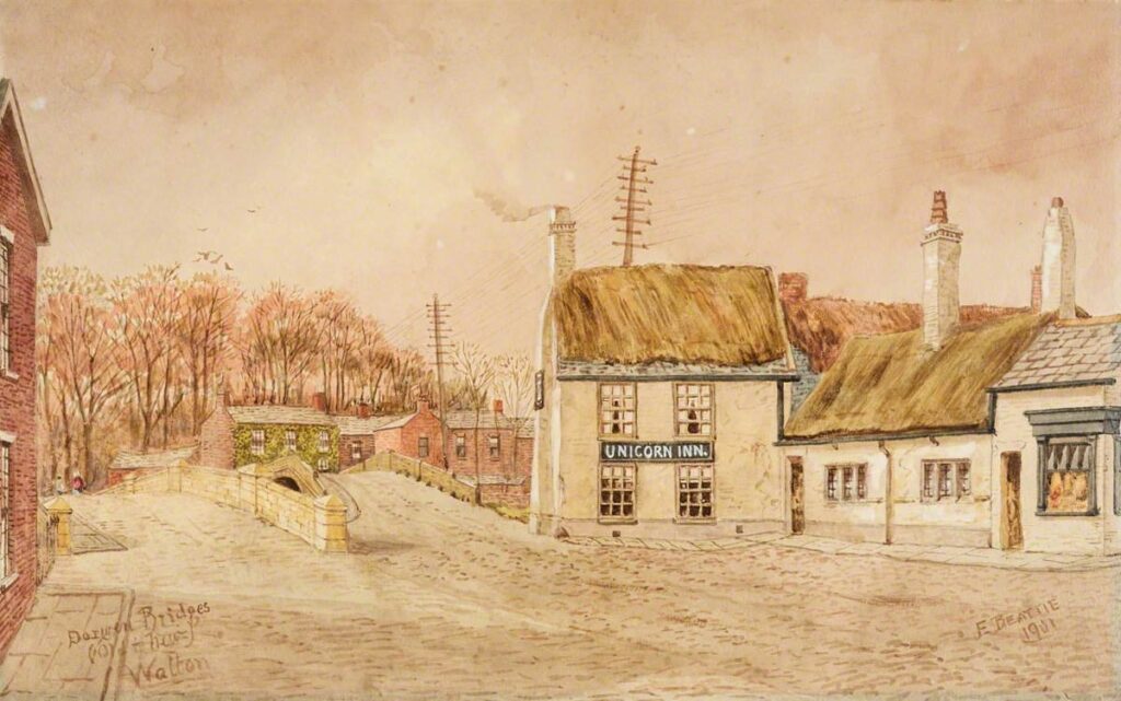
It’s possible (likely) that the old bridge stayed in place for the duration of the construction of the new replacement bridge, as the route would not have been passable. Whilst the newer bridge offers a better position, it could also have been place adjacent, so the existing bridge was available during the construction phase in 1900. However, the positions that are represented in Edwin Robert Beattie’s painting, “Darwen Bridges, Old and New, Walton-le-Dale”, from 1901, has positions that are not realistic.

From the Gale Primary Sources, British Library Newspapers
LANCASHIRE NOTES
Date: Saturday, Dec. 3, 1898
Publication: Blackburn Standard
https://link.gale.com/apps/doc/R3208022258/BNCN?u=lancs&sid=bookmark-BNCN&pg=2&xid=dd16e3dc
~
I didn’t realise until peering over the parapet of the current bridge, in summer 2025, that some of the the former bridge still remains. The masonry visible on the north bank of the River Darwen represents the surviving abutment of the former single-span stone arch bridge, replaced in 1900. The projecting stones are original putlog stones, used to support scaffolding and centring during the construction of the arch.

View from the East
Darwen Bridge, Walton-le-Dale circa 1862. Photographed by Robert Pateson.

View from the West
Darwen Bridge, Walton-le-Dale in 1863. Viewed from Unicorn Pasture and photographed by Robert Pateson.
